Converting ESRI .lpk files to Shapefiles for use in QGIS

Converting ESRI .lpk files to Shapefiles  for use in QGIS
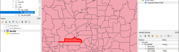
ESRI ArcGIS can export compressed geographic files using the ‘LPK’ file extension. ESRI also have a number of datasets available for free download on their website that use this extension, e.g. the popular North America Postal Areas and Zip Codes datasets. Unfortunately the LPK extension is a proprietary extension not directly supported by other tools, ...

New Maptitude Add-ins for Territories and Vehicle Routing

Caliper have just released two new add-ins for Maptitude: Balanced Territories Add-in This add-in automatically creates a new territory layer from an existing area layer. Each territory is created by combining areas (e.g. zip codes) in the area, whilst attempting to create equal sums of a data field. For example, you could create territories with ...